Railroads have been the arteries of trade and travel across the United States and North America for over a century. Even today, railroad maps and modern tracking tools provide critical insights for industries, travelers, and rail enthusiasts alike. Whether you’re curious about train tracks, want to understand the map of North American railroads, or need a freight train tracker for logistics planning, this guide covers it all (Federal Railroad Administration, n.d.).
What is a Railroad Map?
A railroad map is a detailed representation of railway networks, showing tracks, stations, yards, connections, and sometimes operational details such as train frequency or freight capacity (Federal Railroad Administration, n.d.). These maps help users visualize both current and historical rail systems and can be digital or printed. They are widely used for planning logistics, optimizing freight and passenger transport, studying rail history, and supporting educational projects (North American Rail Map Archive, n.d.).
“Railroad maps are not just static visuals, they are analytical tools,”
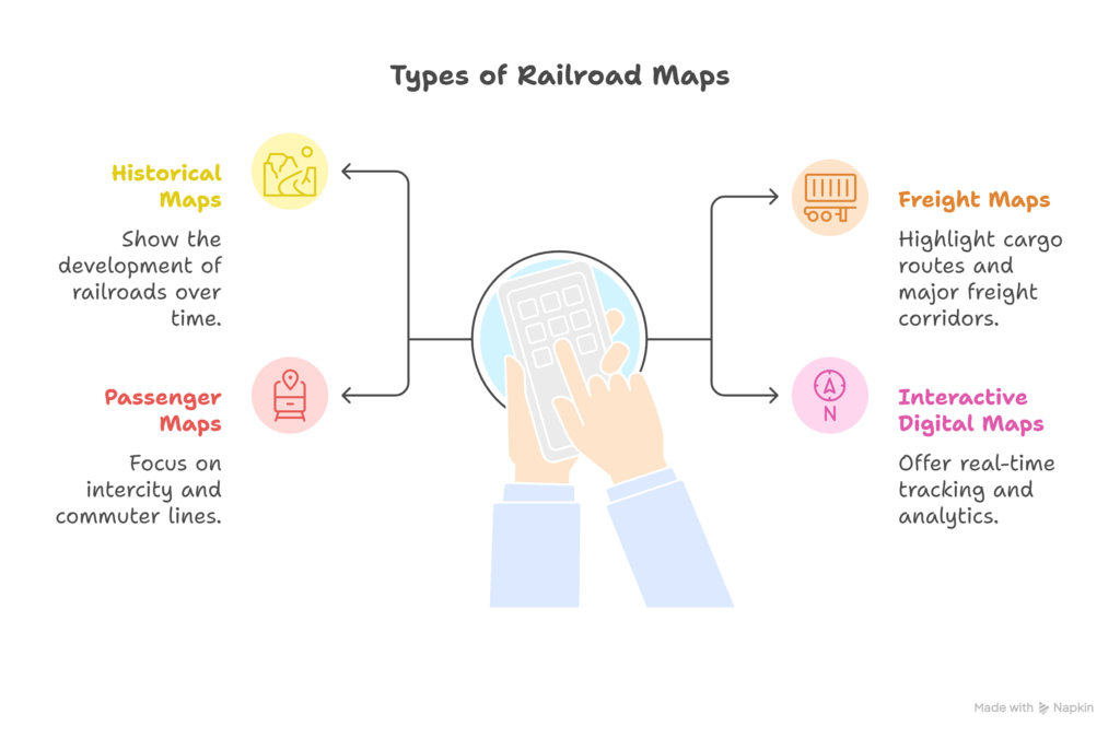
Types of Railroad Maps
1. Historical Maps: Show the development of railroads over time.
For example, 19th-century maps depict the expansion of the Transcontinental Railroad, showing key hubs, branch lines, and the growth of cities along the rail routes (North American Rail Map Archive, n.d.).
2. Freight Maps: Highlight cargo routes and major freight corridors.
For instance, the Union Pacific freight network map shows mainline routes, key interchanges, and rail yards crucial for transporting goods efficiently across states (Union Pacific Railroad, n.d.).
3. Passenger Maps: Focus on intercity and commuter lines.
An example is Amtrak’s national route map, which outlines major passenger routes, stops, and connections, helping travelers plan trips and view service availability.
4. Interactive Digital Maps: Offer real-time tracking and analytics.
Platforms like railroads online map allow users to see active trains, track their movement, view rail yard layouts, and even simulate freight operations for logistics planning or hobbyist modeling (Railroads Online, n.d.).
“Understanding what a railroad map is helps businesses optimize logistics, travelers plan routes, and hobbyists accurately model rail systems.”
How has the transition from paper to digital railroad maps changed planning and logistics?
Why Railroad Maps Still Matter
Railroad maps are more than just historical relics, they are vital tools for understanding how freight, commerce, and connectivity move across North America (U.S. Department of Transportation, n.d.).
Key reasons railroad maps are valuable:
- Navigation: Helps locate active train tracks or find a train yard (Railroads Online, n.d.).
- Logistics: Shippers rely on a railroad map of the USA or a map of US railroads to optimize routes (Federal Railroad Administration, n.d.).
- Education & History: The railroad maps of the United States illustrate how the nation was built (North American Rail Map Archive, n.d.).
- Investment & Planning: Understanding the North American railroad map aids infrastructure and freight planning (U.S. Department of Transportation, n.d.).
“Combining historic maps with digital tools like railroads online map systems helps to predict shipping bottlenecks and improve freight flows.”
How do you think the rise of e-commerce impacts the importance of rail infrastructure in the U.S.?
Exploring Digital Railroad Tools
Modern technology has made railroad exploration easier than ever. Online maps, trackers, and databases provide real-time information for hobbyists and professionals alike (Railroads Online, n.d.).
Popular tools include:
- Railroads Online Map (real-time digital maps).
- Freight Train Tracker (monitor cargo movement live).
- Railroad Connections databases (showing interchange points across states).
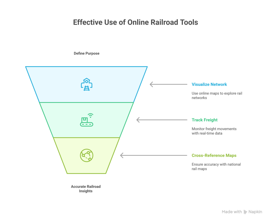
Steps to Use Online Railroad Tools Effectively:
- Identify your purpose. Whether you want to track freight shipments, research historical lines, or simply locate railroads near you for personal interest. Clarifying your intent will determine the right tools to use.
- Use a shipping or railroad online map platform to visualize the network in detail. These interactive maps often allow you to zoom, filter by region, and highlight specific types of rail service.
- For freight movement, rely on a freight train tracker integrated with logistics data. This gives you real-time updates, estimated arrival times, and even cargo details for supply chain planning.
- Cross-reference with a railroad map of the USA for context. This ensures that your digital findings align with the broader national rail infrastructure, making your research or planning more accurate.
“Pairing a freight train tracker with a North American railway map allows companies to anticipate congestion before it affects deliveries.”
What industries benefit the most from real-time freight train tracking?
Finding Railroads Near You
For railfans, travelers, and even urban planners, knowing where the nearest railroads or tracks are can be useful (Federal Railroad Administration, n.d.).
Ways to identify local railroad infrastructure:
- Search “train tracks near me” for basic mapping services.
- Look up “active train tracks near me” for up-to-date operational lines.
- Use local transport department maps to find a train yard near me.
- Explore hobbyist forums that post railroads near me data.
Step-by-Step Approach:
- Start with Google Maps using the keyword train tracks near me. This gives you a general overview of visible rail lines in your vicinity.
- Verify activity with active train tracks near me searches. This helps distinguish between abandoned or inactive rail lines and those currently in operation.
- If interested in freight, check for a train yard near me. Train yards are crucial hubs where trains are assembled, maintained, and redirected, making them essential for understanding local freight activity.
- Confirm with an official United States railroad map. Official maps provide authoritative confirmation of rail routes and can help you cross-check local findings against the national network.
“Urban planners often use a railroad network map of the USA to anticipate future city expansions and industrial zone developments.”
Ready to unlock smarter logistics and leverage rail insights for your business? Explore our Freight Broker Solutions and take control of your supply chain efficiency.
Comprehensive Rail Maps for North America
Rail maps vary from state-level diagrams to continent-wide representations (North American Rail Map Archive, n.d.). The most sought-after resources include:
- Map of North American Railroads (pan-continental coverage) – For example, shows major lines from Canada through the U.S. to Mexico, highlighting key international freight corridors.
- North American Railroad Map (regional rail connectivity) – Illustrates detailed connections within regions such as the Midwest or Northeast, useful for planning local shipping routes.
- North American Railway Map (freight-focused view) – Highlights freight-specific lines and interchanges, showing which routes are preferred for cargo versus passenger travel.
- America Rail Map (broad view of U.S. routes) – Provides a high-level overview of major U.S. rail routes, helping travelers and businesses quickly identify national connectivity.
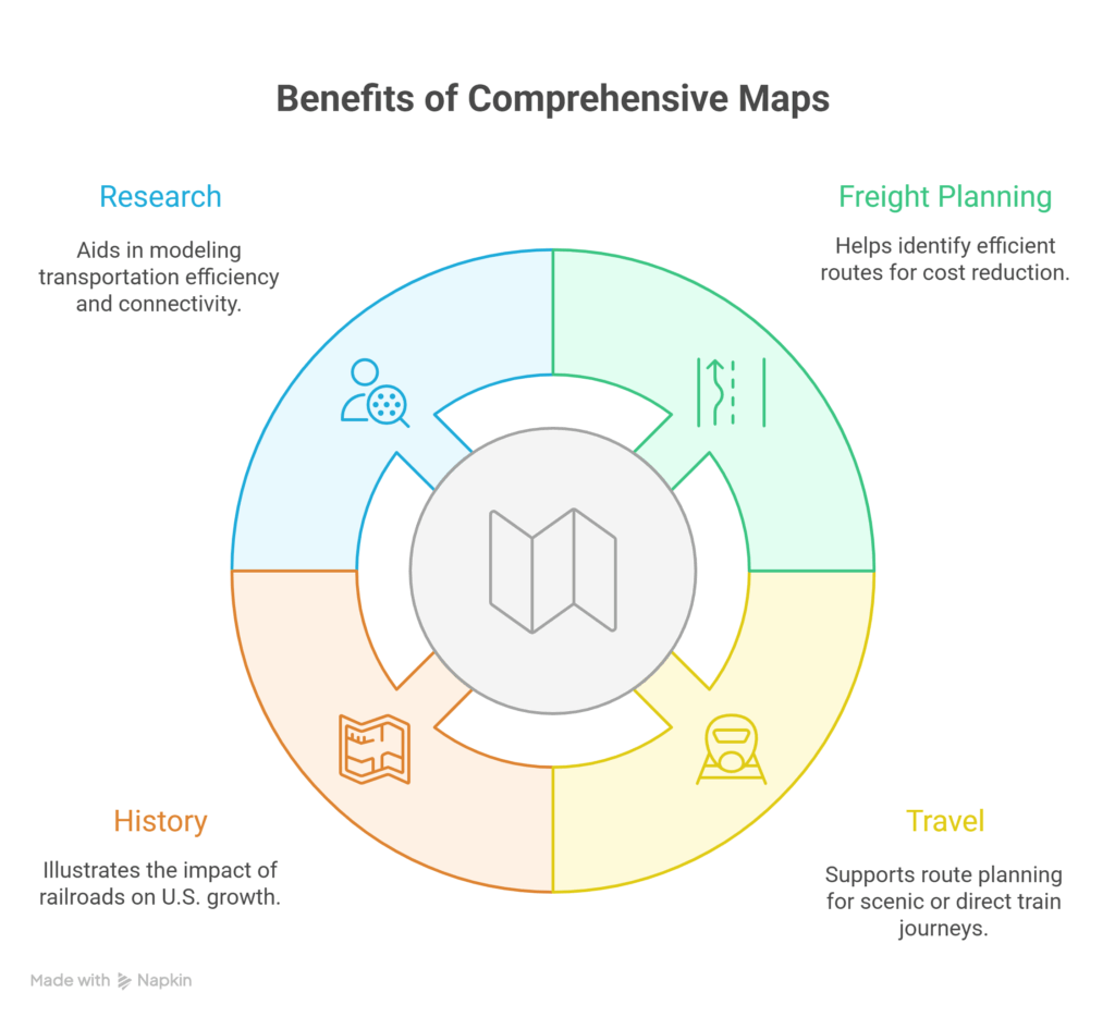
Why comprehensive maps matter:
- Freight Planning: Helps determine the cheapest routes by identifying the most efficient corridors and avoiding congested lines. For example, a logistics company can use a map to choose between multiple east-west freight paths to reduce fuel costs.
- Travel: Supports Amtrak or passenger rail research by showing available routes, station locations, and connections. For instance, travelers planning a cross-country train trip can identify scenic routes or direct lines.
- History: Shows how railroads fueled U.S. growth by illustrating major historic trade and migration paths. Students and historians can trace how rail networks influenced urban and industrial development (North American Rail Map Archive, n.d.).
- Research: Useful for supply chain analysts and students to model transportation efficiency and study regional connectivity. For example, analysts can simulate delivery scenarios using a North American railroad map to optimize cargo movement (U.S. Department of Transportation, n.d.).
Steps to Analyze Rail Maps:
- Start with a map of US railroads for a national overview. Look at the entire network to understand major routes, key hubs, and national freight corridors.
- Layer a map of railroads in the US for specific corridors. Focus on particular regions, states, or lines to see detailed connectivity and intersections.
- Add a rail map of the USA for historic perspectives. Examine historical routes to understand how rail infrastructure developed and how it influences current operations.
- Compare railroad maps of the United States for changes over time. Identify additions, closures, and upgrades to rail lines, helping to track growth patterns and infrastructure evolution.
Railroad Connections and Infrastructure
Railroads aren’t just about lines on a map, they’re about the railroad connections that make freight movement possible (Federal Railroad Administration, n.d.).
Important Resources:
- United States Railroad Map for nationwide perspective – This map shows all major rail lines across the U.S., helping users visualize national freight and passenger networks, identify major hubs, and understand overall connectivity.
- Map of US Railways and map of US railroads for infrastructure details – These maps provide detailed information on track types, junctions, interchanges, and rail yard locations, making them essential for logistics planning and operational analysis.
- Railways in USA Map for educational and planning purposes – Useful for students, urban planners, and researchers, this map illustrates regional connections, rail network density, and integration with other transport modes, supporting both learning and strategic planning.
How to Use These Maps for Planning:
- Identify hubs with major railroad connections. For example, look for key interchange points, major freight yards, or junctions where multiple lines meet to understand where cargo and passengers are concentrated.
- Overlay a map of the USA rail network for full system integration. This helps visualize how local hubs connect with regional and national networks, highlighting route options and potential bottlenecks.
- Cross-check with a US rail map for logistics. Assess track types, line capacities, and freight corridors to plan efficient shipment routes or operational strategies.
- Compare with a USA rail map for passenger relevance. Evaluate which lines serve passenger trains, intercity services, or commuter routes, ensuring planning considers both freight and public transportation needs.
“Freight companies rely heavily on the US railroad map to plan cross-country routes and minimize delays.”
Which is more important today: expanding freight capacity or improving passenger train services?
Practical Applications of Railroad Maps
Railroad maps are not just for specialists; they benefit a wide range of users.
Who uses these maps?
- Businesses: Use the map of railways in the USA to plan supply chains.
- Historians: Analyze the railroad map for cultural and economic studies.
- Hobbyists: Explore a railway map of America for model railroads.
- Travelers: Consult the United States Railway Map to plan scenic journeys.
Applications in Daily Life:
- Students use the US rail map in geography lessons to understand regional transport networks and historical development.
- Shippers check the United States railroad map for freight routing to plan optimal shipment paths and avoid congested lines.
- Tourists find railroads for heritage train rides, exploring scenic or historic rail journeys.
- Urban planners consult these maps to design city expansions around existing rail corridors.
“Transportation analysts note that combining a railroad map of the USA with real-time traffic and freight data helps businesses and public agencies plan for both routine logistics and unexpected disruptions more effectively.”
Looking for smarter ways to move freight or improve your supply chain strategy? Explore our shipping services and see how we can help streamline your logistics journey.
Frequently Asked Questions (FAQs)
1. What is the best online railroad map?
The best online railroad map is the railroads online map, which is popular for providing real-time data. For broader coverage, the North American railroad map is considered highly reliable.
2. How accurate are freight train trackers?
Freight train trackers are accurate within minutes, depending on GPS signals and the data feed. They are widely used by logistics companies for operational planning.
3. Where can I get a detailed map of railways in the USA?
To obtain a detailed map of railways in the USA, official sources such as the U.S. Department of Transportation provide reliable maps. Additionally, commercial publishers release the United States railroad map for public use.
Explore Railroad Maps
Railroad maps and digital tools are essential for understanding, navigating, and planning within North America’s rail network. From logistics optimization to educational projects and hobbyist modeling, these resources provide both practical and historical insights. Integrating railroads online map systems with traditional maps empowers informed decisions, whether for freight, passenger travel, or urban planning.
Ready to leverage smarter mapping tools for your freight needs? Contact us to optimize your logistics with expert guidance.
References
Federal Railroad Administration. (n.d.). Rail network maps. Retrieved from Discover more
Union Pacific Railroad. (n.d.). System map. Retrieved from Discover more
U.S. Department of Transportation. (n.d.). National Transportation Atlas Database (NTAD) – Railroads. Retrieved from Discover more
Railroads Online. (n.d.). Interactive railroad maps and tools. Retrieved from Discover more
North American Rail Map Archive. (n.d.). Historical and modern rail maps. Retrieved from Discover more